
Live Waikiki Surf Report
Waikiki Surf Map: 14 Breaks and Today’s Report
Ratings paused: no live swell reading from the buoy.
Ratings paused: no live swell reading from the buoy.
- Kewalos Advanced
- Ala Moana Bowls Advanced
- Kaisers Advanced
- Rockpiles Advanced
- Fours Intermediate
- Threes Intermediate
- Paradise Intermediate
- Populars Intermediate
- Canoes Beginner
- Baby Queens Beginner
- Queens Intermediate
- Publics Advanced
- Tonggs Intermediate
- Diamond Head Intermediate
Sources and method
- Surf: the spread of breaking wave height across all 14 reefs in the board above, not a single-spot number. One figure for the whole coast would either flatter the smallest reef or undersell the biggest one.
- Wind: NOAA CO-OPS station 1612340, Honolulu Harbour, about 5.5 km from Waikiki. Read 1:42pm HST.
- Swell: NOAA buoy 51212, Barbers Point, in 280 m of water, reading the open ocean swell before this coast has touched it. No live reading right now. The Swell tile above shows a typical south swell so the maps further down this page still have something to draw, and every rating here is paused until the buoy reports again.
- Tide: NOAA CO-OPS station 1612340, Honolulu Harbour, about 5.5 km from Waikiki. Heights are feet above mean lower low water, the chart datum tide tables are written in, so the current reading and the turns beside it are the same measure. Read 1:42pm HST.
- Water: NOAA CO-OPS station 1612340, Honolulu Harbour, about 5.5 km from Waikiki. Read 1:42pm HST.
- Air: NOAA CO-OPS station 1612340, Honolulu Harbour, about 5.5 km from Waikiki. Read 1:42pm HST.
These are observations, not a forecast: each one is the latest reading from its source at the time stated. The rating above is our own measurement, computed from them, and it is not Surfline's rating. For the outlook, see Surfline.
Where to Surf
Beginner
Picks paused: no live swell reading from the buoy.
Intermediate
Picks paused: no live swell reading from the buoy.
Advanced
Picks paused: no live swell reading from the buoy.
How the Waves Differ, Break by Break
The stretch between Kewalo Basin and Diamond Head holds a string of reef breaks, and they are not interchangeable. Canoes gives a first-timer a long, forgiving ride all the way to the sand. Publics puts an unprepared surfer on shallow rock. This guide sorts the south shore by what each break actually asks of you.
The same south swell hits every one of these reefs, and every reef does something different with it. Canoes spills slowly in both directions and carries you a long way toward the sand. Queens, a few hundred metres east, holds a defined right that runs faster and asks more of you.
Zoom in for a closer look at a single reef: use the buttons, pinch on a trackpad or touchscreen, or double-click the map. Drag to move around once you are in.
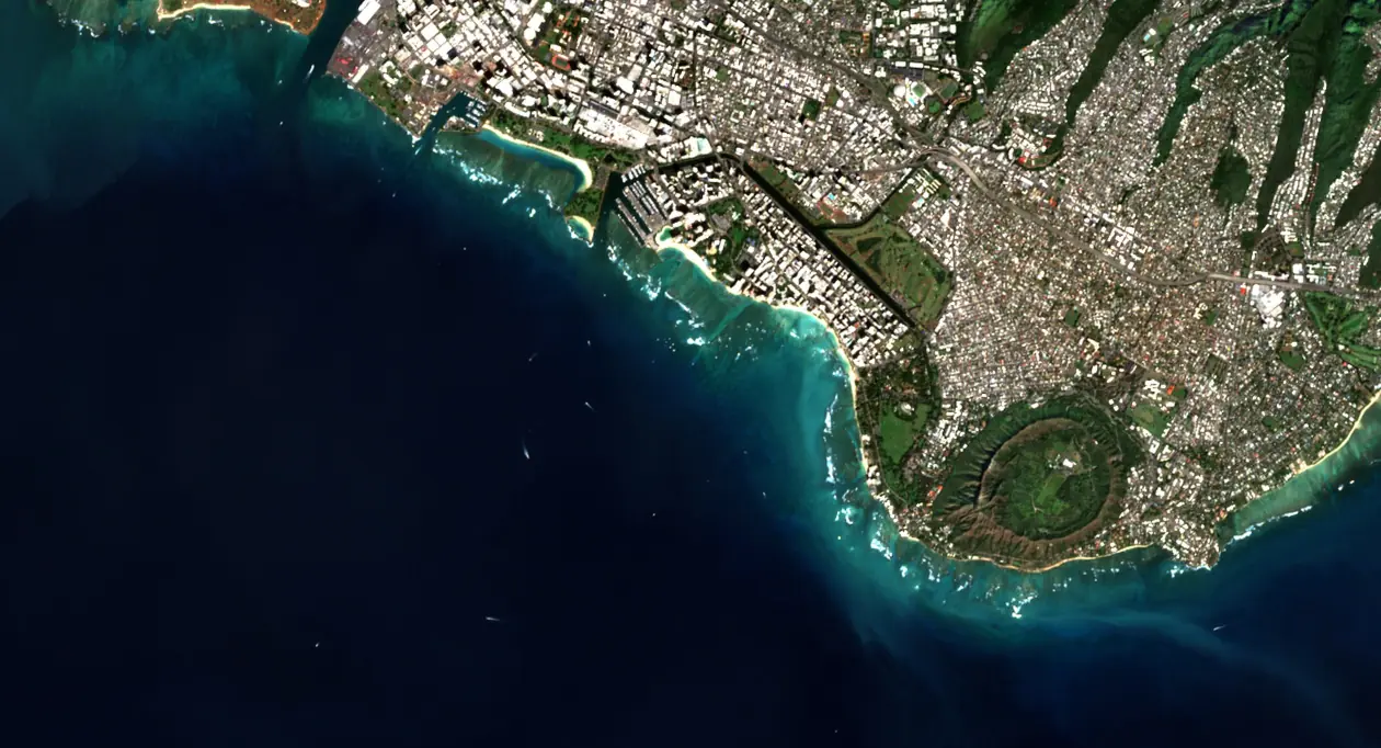
The map is a satellite photo of this coast with the water coloured by modelled wave height: the swell from the buoy when it has a reading, otherwise a typical south swell, grown as the seafloor shallows and bent by the reefs, from NOAA NCEI CUDEM depths. It shows where the bottom lifts and focuses the swell, not a forecast. The white streaks travel the way the swell runs, at its speed for the depth, sped up, so they slow as they reach the reef. The swell height and period come from the NOAA buoy off Barbers Point, station 51212, which sits in 280 m of water and so reads the open ocean swell before this coast has touched it. That is an observation from the time stated, not a forecast, and what happens to it here is a model: linear refraction only, no diffraction, no currents, and no wind effect on the wave shape itself. For a forecast use Surfline, Windy or NOAA. Coastline data © OpenStreetMap contributors, ODbL. Satellite image: Contains modified Copernicus Sentinel data 2026.
Reading the Waikiki Surf Breaks Map
Summer is the season
Apr–Sep South swells from the Southern Hemisphere wrap into Waikiki through the warmer months, averaging roughly 2 to 4 feet. In winter the swell energy shifts to the North Shore and the south shore goes quiet.
Surf the morning
Dawn Water is usually cleanest before the trade winds fill in. By afternoon the onshore wind adds chop, and the beginner lineups are at their most crowded.
It is all reef
Coral Nearly every break here sits over shallow coral. That is what shapes the long, peeling waves, and it is why a wipeout at low tide has real consequences. Match the break to your level.
The Breaks, West to East
Wind speed and direction come from NOAA CO-OPS station 1612340 in Honolulu Harbour, about 5.5 km from Waikiki (inside a harbour, not on the open coast), so it is the nearest wind measurement available rather than the wind at the break itself. Each break card weighs that reading against its own seaward orientation to say whether it is offshore, onshore or cross-shore there.
The westernmost wave on this stretch, breaking outside the mouth of Kewalo Basin harbor. It is fast and shallow, it closes out hard on the inside, and it draws a committed crowd of surfers and bodyboarders who all know exactly where the reef is. The harbor channel beside it makes the paddle out easy, which is the only forgiving thing about the spot.
History
In 1913 the Territory of Hawaii bought the Kewalo fishery from the Ward family for $1,800. By 1925 it had a harbor there instead: Kewalo Basin, with an entrance channel cut through the reef.
The surf breaks beside that channel, and the fishing and tour boats still run through it.
Tips
- Paddle out from Kewalo Basin Park and keep clear of the harbor channel: boats come and go through it.
- The right is shallower and faster than the left.
- Best on a south swell with northeast trades, which blow offshore here.
- The crew here is committed and knows the reef. Sit wide and watch a few sets before you go.
When a real south swell lands, Bowls is one of the best waves on the whole south shore. It breaks near the Ala Moana Boat Harbor, fast and hollow, and the lineup is firmly a locals' wave. Watch it, respect it, and only paddle out if you are genuinely at home in punchy reef surf.
History
On September 13, 1965, John Kelly of Save Our Surf warned the state that the walls planned for Magic Island would "completely destroy all 20 sites from Ala Wai boat channel to Kewalo channel." On a good summer day, he wrote, more than 1,500 surfers used them.
The reef had already been reshaped once. The Ala Wai entrance channel beside Bowls was dredged in 1951, and Magic Island went in on the reef flat in 1964.
Bowls survived both. The World Surf League has run its Local Motion Surf Into Summer qualifying contest on it.
Tips
- Paddle out from the small beach by the Ala Wai Boat Harbor and cross the harbor channel quickly: boats use it.
- The left is the wave. The right is shorter and closes out once it gets big.
- This is one of the most crowded lineups on the south shore. Wait your turn and do not paddle around the pack.
- Check it from the end of Magic Island before you commit.
A punchy performance wave toward the Hilton and Ala Moana side, mainly a bowly right with a softer left beside it. It rewards surfers who can take a steep drop and set a line quickly, and the lineup can be territorial. This is a spot to earn, not a spot to learn.
History
In 1954 Henry J. Kaiser and Fritz Burns bought land at the west end of Waikiki. Kaiser dredged a channel so commercial catamarans could reach his beach, and in 1955 he opened the Kaiser Hawaiian Village.
Conrad Hilton bought the hotel in 1961 and put his own name on it. The surf on the west margin of Kaiser's channel kept the old one.
Tips
- It lines up off the Hilton Hawaiian Village, beside the catamaran channel.
- The reef is shallow and covered in urchins. Give yourself some tide and never stand up on it.
- Best on a south or southwest swell with northeast trades.
- The takeoff is tight and the regulars sit in it. Wait your turn.
A heavy left over the shallowest reef on the Ala Moana stretch, named for exactly what is underneath it. It needs real size before it starts working and it punishes a late takeoff, so the lineup stays small and experienced. Booties are a sensible idea and a small day is not worth the paddle.
History
When the surf historian John Clark ran down the Waikiki breaks for Hawaii Public Radio in 2021, he ended here: "Publics, Canoes, Populars, Threes, Fours, Kaiser's and finally Rock Piles outside the Ala Wai Harbor and Hilton lagoon."
Tips
- Fast lefts over sharp, shallow rock and reef: experienced surfers only.
- Steer around the shallow reef straight off the beach on the way out.
- It needs a solid south swell to break properly.
- Not the North Shore Rockpile near Pipeline. Make sure the forecast you are reading is for the south shore.
The fourth peak counting out along the Ala Moana reef, sitting between Rockpiles and Threes, in front of Fort DeRussy. It is mainly a left, punchier and shorter than the long right at Threes next door, and it keeps its shape across a wider range of swell, which makes it a fair step up for anyone already comfortable there. It fills in fast once a south is running.
Tips
- It lines up off the U.S. Army Museum at Fort DeRussy.
- It wants a bit more swell than the breaks inside it. On small days it barely breaks.
- Surfers and bodyboarders share the peak.
- Mind the reef at low tide.
The third recognizable break in the lineup, and a clean one. Threes is a right that peels into a semi-channel over sand, holds its shape at nearly any size, and works best on a lower tide. It gets crowded when it is on, but the vibe runs friendlier than neighboring Kaisers. You may recognize it from the film Endless Summer.
Tips
- Paddle out from the small beach in front of the Hale Koa Hotel at Fort DeRussy. It is about half a mile out, so save some energy.
- Lower tides are best. At high tide it goes fat.
- When it is on, the lineup is among the most competitive on the south shore.
- Expect currents in the channel beside it on bigger days.
Big, rolling, shifting peaks in deeper water. Paradise is a favorite of longboarders and stand-up paddlers who want long rides and room to spread out. It is swell dependent, so it needs some size to turn on.
Tips
- A longboard and SUP wave. The peaks shift, so sit wide and move with them.
- It needs a mid-size or bigger south swell to break.
- The crowd spreads out over several peaks, which makes it a good escape when Canoes and Queens are packed.
A long right over a sand-covered reef that breaks outside Canoes. The long paddle keeps crowds lighter than the inside spots, and it handles bigger south swell well, though a stiff trade wind can chop it up. The spot sits on Kawehewehe, an ancient Hawaiian healing site.
History
The water off Gray's Beach and the Halekulani is Kawehewehe, "the removal." The sick came here to bathe. A kahuna put a lei of limu kala on the patient, who ducked under, let the sea take the lei, and did not look back.
Surfers kept a shorter name for the wave outside it: Populars.
Tips
- It breaks far outside, so plan for a long paddle.
- A long right over sand and reef that works on any south swell from chest high up.
- It stays cleaner than most of Waikiki once the trades blow, and it is usually less crowded than Canoes and Queens.
- Afternoon trades can chop it up. Go early.
The most famous beginner wave in Hawaii, straight out from the heart of Waikiki. Waves roll slow and soft in the 1 to 3 foot range and give you a long, forgiving ride to the sand. It is also the most crowded break here, shared with surf schools, outrigger canoes, catamarans, and SUPs, so paddle out early and keep your head up.
First time on a board? Compare seven Waikiki surf schools and five board rental shops.
History
In November 1912 a magazine for Navy men printed an account of Waikiki surfing under Duke Kahanamoku's name. At the "canoe" surf off the Moana, it said, board riders "dispute rights with the outrigger canoes that come sliding in from a mile out at sea."
The canoes had a clubhouse by then. Alexander Hume Ford opened the Outrigger Canoe Club in May 1908 on the sand between the Moana and the Seaside Hotel, in two grass houses on land leased from the Queen Emma estate for $10 a year.
The club left the beach in 1963. The canoes are still in the lineup.
Tips
- Outrigger canoes and catamarans come through fast and cannot turn easily. Stay out of their path.
- Best at low to mid tide on a south swell.
- It is the busiest break in Waikiki. Paddle out early and keep your head up.
- Do not stand on the reef: it is living coral, and there are urchins.
The small, forgiving wave tucked just inside Queens, a short walk from the sand at Queen's Surf Beach. It breaks soft and slow over a shallow shelf, which is exactly why it is where lessons happen and where kids catch their first ride. The tradeoff for that gentleness is a thin bottom and a lineup packed with beginners, so keep your board under control and your head up.
First time on a board? Compare seven Waikiki surf schools and five board rental shops.
Tips
- Small, soft waves just off the Kuhio Beach wall: a first-timer and kids' wave.
- The bottom is shallow and partly living reef with urchins. Fall flat and do not stand on it.
- Mid to high tide gives you more water over the reef.
- This is not Queens. The bigger wave further out is a different break and a different crowd.
The heart of traditional longboarding in Waikiki and a longtime contest wave, breaking in front of Queen's Surf Beach near the Duke Kahanamoku statue. It is a shapely right with the occasional short left, and the lineup is skilled and locally respected, so it is not a lesson wave. First-timers and kids should use Baby Queens, the small, gentle inside zone right next door.
History
Larry Kerr said he surfed here between 1900 and 1905, and that Queen Liliuokalani, watching from her beach home, would tell her attendants to "get those two haole surfers" to surf for her. A 1975 Star-Bulletin story credited Kerr and Edward "Dude" Miller with naming the break Queen's Surf.
The city bought a beachfront mansion here in 1946 and it became the Queen's Surf restaurant. It closed on December 31, 1969, and was torn down in 1971 to make room for the park. The surf historian John Clark points to a banyan on the lawn: "their imu pit was right where that tree is."
Tips
- It sits just east of Canoes, off the Kuhio Beach end of Waikiki.
- It gets a little hollower at low tide and fatter at high tide.
- Some of Hawaii's best longboarders surf here, and the lineup is competitive. If you are still learning, stay on the inside at Baby Queens.
- Respect the order: whoever is deepest has the wave.
Past the Waikiki Aquarium, Publics is a fast, hollow left over shallow, rocky reef. Takeoffs are pitchy and falls carry real consequence, especially at low tide, so it is strictly an experienced-surfer wave. The upside: it tends to be less crowded than the central breaks. Booties are a good idea.
History
Paddle out at Publics and you can hit cold water in a warm sea. The surf historian John Clark, who calls this his favorite spot, says those patches are fresh water from springs rising through the bottom. Waikiki, he notes, means "bubbling springs."
Clark dates Duke Kahanamoku's famous long ride to 1916: a left caught at Kalehuawehe, outside this reef, ridden all the way to the Moana Hotel.
Tips
- The inside is shallow and sharp. Surf it at mid to high tide.
- It breaks in front of the Waikiki Aquarium. Park along Kapiolani Park behind the beach.
- Best early, before the trades, or on a northeast wind.
- The crowd is lighter than central Waikiki, but the wave is for experienced surfers.
A short, mellow left past Publics toward Diamond Head, in front of what was once the Tongg estate. It breaks close to shore over reef and it switches on at a smaller size than most of this coast, which is why people check it when the rest of Waikiki has gone flat. The takeoff zone is tight and the lineup polices itself.
Tips
- Paddle out through the Kapua Channel by Kaimana Beach.
- The inside gets shallow at low tide.
- It is open to the trades, so go early or on a more northeasterly wind.
- It breaks at smaller sizes than most of Waikiki and is rarely as crowded.
The reef below Diamond Head Road, where Cliffs and Lighthouse break within sight of each other. It is far more exposed than anything inside Waikiki, so the trades get to it most afternoons, but it also picks up swell the inside reefs miss and the crowd thins out because no hotel is within walking distance. Park along the road and pick your way down.
History
Hawaiians call the crater Leahi. In the story the state House retold in 2023, the goddess Hiiaka named it for the brow of an ahi, a tuna, which the ridge resembles.
The lighthouse on the point below it was first lit on July 1, 1899. The two best-known breaks here are Lighthouse and Cliffs.
Tips
- Park along Diamond Head Road, check the surf from a lookout, then take the steep path down to the beach.
- Cliffs, straight out from the beach, has long mellow waves. Lighthouse is faster and shallower.
- Go early. The trades reach this shore by late morning.
- The entry is rocky reef. Time it between sets.
Before You Paddle Out
A few things that keep you safe and keep the lineup friendly.
Match the break to your level
Start at Canoes or Baby Queens. Working your way out to reef breaks like Publics or Bowls before you are ready puts you and others at risk.
Wear reef-safe sunscreen
Chemical sunscreens that harm coral are banned in Hawaii. Bring a mineral, reef-safe one, even on cloudy days.
Never ditch your board
In a crowded, shallow lineup a loose board is dangerous. Hold it or turn turtle, and always look before you take off.
Respect the local order
Do not drop in, wait your turn, and read the vibe. Waikiki is welcoming, but the peak belongs to whoever is deepest.
Waikiki Surf Breaks Compared
Every break on this stretch of coast, side by side. Sorted west to east, the same order as the map and the list above.
| Break | Level | Wave | Bottom | Crowd | Also worth knowing |
|---|---|---|---|---|---|
| 1 Kewalos | Advanced | Fast, shallow bowl | Thin reef | Committed, bodyboards too | Best on: South swell |
| 2 Ala Moana Bowls | Advanced | Hollow, fast peak | Shallow reef | Heavy, local | Best on: Solid south swell |
| 3 Kaisers Kaiser Bowls | Advanced | Bowly right, softer left | Reef | Competitive | Best on: South swell |
| 4 Rockpiles | Advanced | Heavy left | Shallow rock and reef | Small, experienced | Best on: Solid south swell |
| 5 Fours | Intermediate | Punchy left | Reef | Moderate | Best on: South swell |
| 6 Threes | Intermediate | Right, into a channel | Sand over reef | Busy when firing | Best tide: Lower |
| 7 Paradise | Intermediate | Rolling, shifty peaks | Spread out | Board: Longboard / SUP · Best on: Mid to larger south | |
| 8 Populars Pops, Kawehewehe | Intermediate | Long right | Sand over reef | Access: Long paddle · Watch for: Trade-wind chop | |
| 9 Canoes | Beginner | Slow, rolling, both ways | Reef and sand | The busiest in Waikiki | Best for: First-timers, lessons |
| 10 Baby Queens | Beginner | Tiny, soft, both ways | Shallow reef | Lessons and beginners | Best for: First-timers, kids |
| 11 Queens | Intermediate | Shapely right, short left | Skilled, respect the order | Board: Longboard heaven · Beginners: Use Baby Queens inside | |
| 12 Publics | Advanced | Fast, hollow left | Shallow rocky reef | Lighter | Avoid at: Low tide if unsure |
| 13 Tonggs | Intermediate | Short left | Reef | Tight, local | Best on: Small to mid south |
| 14 Diamond Head Leahi | Intermediate | Shifting peaks, lefts and rights | Reef and rock | Best on: South to southeast · Watch for: Trade-wind chop |
Skill level is the break at its ordinary size. Every one of these reefs gets harder as the swell climbs, and a beginner break on a big south is not a beginner break that day. Check the live report at the top of this page before you paddle out.
How a Wave Works
A teaching diagram, not to scale.
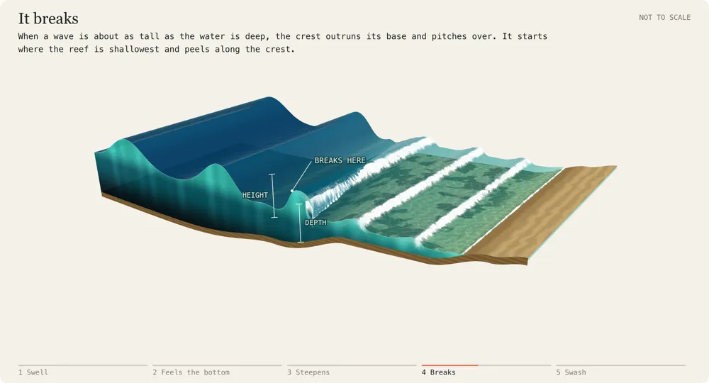
A still of the moment the wave breaks. The animated version needs a browser that can draw WebGL.
Reduce Motion is on, so this starts paused on the breaking frame. Press Play to run it.
What the bottom does to a wave
A wave is shaped twice: first by the storm that made it, then by the seafloor it crosses on the way in. Here is what each one changes.
Swell period
Out at sea the period, the time between one crest and the next, sets how long and how fast the waves are. A 14-second south swell has crests about 300 m apart and travels around 22 m/s (about 49 mph). The bottom has no say yet.
Depth: feeling the bottom
A wave starts to feel the bottom once the water is shallower than about half its wavelength. For that 14-second swell that is roughly 150 m down, far outside the reef. Longer-period swells feel the bottom sooner and carry more energy into the break.
Shallower water
In shallow water a wave’s speed depends only on depth: in 3 m of water it moves about 5.4 m/s (about 12 mph). Waves behind are still in deeper, faster water, so the crests crowd together (a shorter wavelength) and the same energy stacks into a taller, steeper wave. The period never changes.
Depth at the reef
A wave breaks when it is about as tall as the water is deep (roughly 0.8 times the depth). A shallow reef trips small waves; a deeper one only breaks bigger swell. That is why each break has its own best size.
How steep the bottom is
A gentle slope lets the crest crumble over slowly, the soft rolling waves of Canoes and Populars. A sudden, shallow reef edge makes the lip pitch out ahead of the wave, which gives the hollow, fast waves at Ala Moana Bowls and Publics.
The reef's angle to the swell
Where the reef edge runs at an angle to the waves, one end reaches shallow water first, so the break peels along the crest instead of closing out all at once. That is what makes a wave rideable, and whether it runs left or right.
The reef's shape
The part of a wave over shallower water slows first, so crests bend toward shallow reefs and wrap around them. It is why some breaks only work on certain swell directions.
After it breaks
The whitewater keeps rolling over the shallow reef, losing height as it goes, until it runs up the sand as swash and drains back as backwash, just as the next one arrives.
More Oahu Guides
The rest of what we have written about the island, for the hours you are not in the water.